 DSNews The homepage of the servicing industry


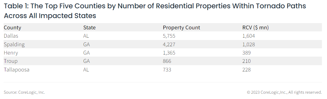
 According to CoreLogic, hail, straight-line winds, and tornadoes from a January 12 severe thunderstorm system damaged approximately 16,800 properties across areas of Mississippi, Alabama and Georgia. CoreLogic estimates the overall damage to these single- and multifamily residential properties was a combined reconstruction value (RCV) of $4.5 billion. Not all properties within the tornado footprint suffered damage. A damaged structure may not have suffered 100% loss up to the full reconstruction value.
A single supercell thunderstorm traveled more than 550 miles across multiple states, responsible for the most severe tornadoes, in terms of intensity and size of impacted region. A cold front moved eastward across the southern U.S. on Jan. 12, leaving behind a path of destruction in the form of hail, tornadoes, and severe straight-line winds. According to NOAA, there were more than 20 tornado reports across Mississippi, Alabama and Georgia, as well as more than 40 hail reports from Oklahoma to West Virginia.
Tornadoes were recorded starting in Selma, Alabama, and continuing northeast into Georgia, as the National Weather Service (NWS) reported that the Selma tornado reached EF-2 status with estimated peak wind speeds of 130 miles per hour.
The National Oceanic and Atmospheric Administration (NOAA) Storm Prediction Center (SPC) reported tree and structural damage in Selma, Alabama, including heavy damage at the Selma Country Club. The NWS post-event survey noted roof and foundation damage to several manufactured homes, and heavy exterior wall damage to structures throughout Selma.
The severe weather was responsible for widespread power outages across Alabama and Georgia, and more than 160,000 customers were without power as of Jan. 12 at 5:25 p.m. EST, according to poweroutage.us.
The January 12th cold front dropped hail ranging from three-quarters of an inch, to more than two inches across southeastern U.S. CoreLogic Hail Verification Technology has mapped two-inch diameter hail in Shelby County, Alabama, approximately 15 miles southeast of downtown Birmingham, Alabama. Two-inch diameter hail is slightly larger than a golf ball and can fall at speeds close to 40 miles per hour, according to National Oceanic and Atmospheric Administration (NOAA) National Severe Storms Laboratory (NSSL). This size of the hail is considered “Very Large Hail” by the NWS, and is able to cause moderate damage to property such as buildings, automobiles, and agriculture. Hail with a diameter greater than one inch was also recorded near Nashville, Tennessee, north of Greenville, South Carolina, and northeast of Atlanta, Georgia.